Super Typhoon Yolanda

A Case Study in Remote Sensing-Based Disaster Response

[OVERVIEW]

How do communities recover after a typhoon?

Every year, the Philippines loses lives and billions of dollars in economic damage to typhoons—and climate change is only making these disasters worse. In fact, the Philippines is among the few countries that are most at risk from the climate crisis. 

Filipino communities must therefore use innovative strategies to respond to disasters. Here we demonstrate one such strategy. Using satellite imagery from NASA's Black Marble, we created interactive visualizations that can help in assessing damage or designing early-warning systems. To demonstrate this, we focus on Super Typhoon Yolanda—the most destructive typhoon that has devastated the country.

Super Typhoon Yolanda: A Briefer

Striking in November 2013, Supertyphoon Yolanda (international name "Haiyan") was then the strongest storm ever recorded in world history. This disaster was a pivotal moment in Philippine history, forever shaping disaster management policies and marring Filipino memories—a reminder of the cost of the climate crisis. Two of our team members, Hillary and Hans, barely survived the storm as children.

Mapping Yolanda's Impact

The eastern regions of the Philippines bore the brunt of Yolanda's destructive power, especially the region of Eastern Visayas. According to the official report by the National Disaster Risk Reduction and Management Council, 93% of the national total of 6,300 casualties came from this region. Eastern Visayas also suffered the greatest damage in the country, accounting for 72% of the national cost of damages.

The region is divided into six provinces: Leyte, Southern Leyte, Biliran, Samar, Northern Samar, and Eastern Samar. Each province is further divided into municipalities and cities. The province of Leyte accounts for an overwhelming 92% of casualties in the region. Leyte's capital city, Tacloban City, suffered the most among all the region's municipalities.

Explore the maps below to situate yourself in the impact area.

Seeing Disaster from Space with Nighttime Lights

NASA's Black Marble data product contains openly available satellite data on human-made nighttime lights. The lights captured in this product include street lights, storefront lights or signs, overflow from indoor lighting, and vehicle lights. 

Black Marble data has been used for various research applications on topics such as light pollution, urban expansion, fires, and disaster impacts. Given that typhoons and other natural disasters typically cause electricity outages, nighttime radiance can serve as a proxy for disaster impact and recovery.

Inspired by this study which used Black Marble data to assess recovery after Hurricane Maria in Puerto Rico, we set out to do a similar study on the post-Yolanda Philippines. We focus our analysis on Eastern Visayas, the region that sustained the greatest damage from the typhoon. Notice how Eastern Visayas dims in the animation.

VISUALIZING RECOVERY

November 6, 2013

A QUICK LOOK

Above are three animated images showing raw Black Marble data focusing on Tacloban and Ormoc, two main cities in Eastern Visayas. For comparison, we show Cebu City, a neighboring metropolitan area that was not as affected by Yolanda.

Tacloban City
The contrast between the night before landfall (November 8th) and the night after (November 9th) is striking and sudden: an area of ten bright orange or yellow pixels in the core of the city gets reduced to two; the less dense parts of the area, previously colored in purple and red, go almost completely black. Even one year later, the city had not recovered its pre-Yolanda brightness. Quantitatively, Tacloban’s radiance fell to only 9% of its pre-typhoon level. On the second night, it was 28% as radiant, and on the third only 49%. 

Ormoc City
In Ormoc, we see a similar trend, though it is harder to tell as the city is not as bright as Tacloban. On the first, second, and third night, Ormoc was at 57%, then 34%, then 63% of its pre-typhoon brightness - Ormoc was strongly impacted but not as devastatingly as Tacloban was. And in Cebu, we see only a minor dampening in brightness on the night of the storm; the city has easily recovered one year out. Indeed, for both Tacloban and Ormoc, we see a sharp decline in November 2013, corresponding to Yolanda’s landfall. 

A CLOSER LOOK

Explore the interactive heatmap below to see how each municipality recovered over the 6 months after Yolanda. From these "barcodes" it is immediately obvious which municipalities sustained particularly catastrophic damage.

Strikingly, Tacloban's brightness never returned to pre-Yolanda levels in the time period considered for this project (through mid-2014), whereas Ormoc city can be said to have recovered by then. After 6 months, Tacloban remained at 55% brightness, i.e., marginally above the third night. Ormoc, however, had recovered to 105% of its pretyphoon radiance — they managed to recover completely and then some. 

What other patterns do you see?

Looking to the Future

New climate action​ policies since Yolanda
Since Yolanda struck, the Philippines has used numerous policy tools to increase disaster resilience and climate action. For example, in 2021, the Philippines committed to one of the most ambitious Nationally Determined Contributions (to act on climate in response to the Paris Agreement) in Southeast Asia: a 75% reduction of national emissions from 2020 to 2030 (Republic of the Philippines, 2021; USAID, 2023). It aims to achieve this commitment primarily by increasing the share of national energy consumption derived from renewable sources (USAID, 2023). In addition, in November 2023, the country’s legislature proposed The Climate Accountability Act (CLIMA) which would hold corporations responsible for their contributions to climate change (Bradeen et al., 2023). CLIMA would be the first in the world to create a national loss and damage-focused legal framework (Bradeen et al., 2023).

The Philippines is not meeting its commitment to climate action
However, the Philippines is so far not on track with its Nationally Determined Contribution (Climate Analytics, 2021; Climate Action Tracker, 2023), and the nation continues to experience vulnerability to the accelerating climate crisis. It is clear that international assistance will be necessary for the Philippines to meet its emissions target (Climate Analytics, 2021), yet in the aftermath of Yolanda, a disconnect between the national government and local governments led to mismanagement and poor distribution of aid (Eadie, 2019; Salazar, 2015). Increased communication and collaboration between levels of government is crucial in optimizing disaster and climate response going forward, particularly in acute situations such as directly following a typhoon.

Remote sensing for disaster response
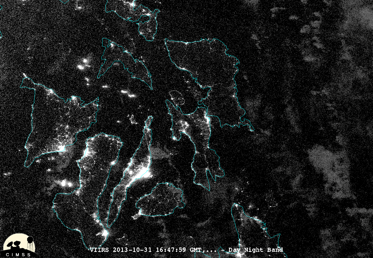
Remote sensing data, such as Black Marble imagery, can be used to aid in these cross-cutting environmental efforts. Black Marble nighttime lights data can serve as a preliminary assessment for utilities and local governments of electricity outages after a storm, and can help prioritize support (Román et al., 2019). In addition, remote sensing data can be integrated into climate and storm early warning systems to alert and prepare households and communities in case of emergency (Bello & Aina, 2014). In this project, we’ve demonstrated a municipal-level use case of Black Marble data that could be applied to such early warning systems or outage assessments.

OPEN SCIENCE

This visualization project was created for the Pale Blue Dot Visualization Challenge. In line with the challenge's goal of promoting open science, we only used publicly available data and free, open-source tools to create our visualizations. 

We also make our methods and source code publicly available. To learn more, visit our Background and Methods pages as well as our Github repository.

Team Dunkin 🍩

(so named because most of us met in college in Massachusetts)

Hillary Diane Andales

Hillary is an astrophysics PhD student and science communicator. 

Tyler Stotland

Tyler is a geospatial analyst and environmental scientist based in Burlington, VT.

Faraz Masroor

Faraz is an economic analyst based in New York City. 

Hans Newton Andales

Hans studies computer engineering at the University of the Philippines - Diliman.